Goals and Background:
In order to complete Lab 5, I
needed a well-structured background on map overlay and geoprocessing to
perform the correct relationships between layers. To attain the knowledge
I would need to accomplish this, my professor established interactive examples
that examined functions/tools such as clip, erase, dissolve, intersect, and
union. I also completed tutorials that emphasized these points as well as
walked me through the processes in making dataflow models. The goal of
Lab 5 was to demonstrate my understanding of geoprocessing tools and dataflow
models to examine suitable bear habitats in Marquette County, Michigan and
explore the basics of python scripting by analyzing the development of tourist
resorts in Wisconsin and air pollution zones near interstates in
Wisconsin. As a result of completing this lab, a map of Marquette County,
MI and two maps of Wisconsin displaying their respective goals along with
dataflow models of each part of the lab will highlight my awareness of
geoprocessing tools in ArcGIS.
Methods:
I began this lab by unzipping the
supplied files and exploring each file type and coordinate system. Moving
on, I found I was given minimal data for bear_locations. In order to
determine the relationship between this feature class and the land cover type,
I used the 'intersect' tool to develop a new feature class called 'bear_cover'
that gave me the land cover information I needed to proceed. With new
criteria given to me pertaining to river resources for bears, I used a 'buffer'
tool to create a distance of 500 meters surrounding a stream. To clean
this data up, I also performed the use of the 'dissolve' and 'clip'
tools. Once I selected the appropriate land covers (Mixed Forest Land,
Forested Wetlands, and Evergreen Forest Land), I used the 'intersect' tool to
intersect appropriate land covers and distances within rivers to find the ultimate
suitable bear habitat.
I was then given more criteria disclosing DNR management
lands and that these restoration areas should exclude areas within 5 kilometers
of Urban or Built-up lands. Therefore, I performed clipping and
dissolving on DNR management lands to analyze those within the area of
study. I also performed a buffer and used the 'erase' tool to exclude
within the areas mentioned previously. Each tool used within this part of
the lab can be found in the data flow model below (Figure 1).
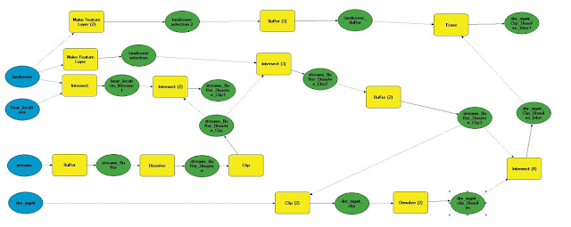 |
| Figure 1. Data flow model for criteria pertaining to suitable bear habitats and DNR management areas. |
In part two of the lab I performed
the python scripts shown below and developed more data models that explain each
tool I used in the process of developing my final maps/analysis. Figure 2
through 5 illustrate lake resorts in WI (Section 1) and figures 6 and 7
display air pollution impact zones in WI (Section 2).
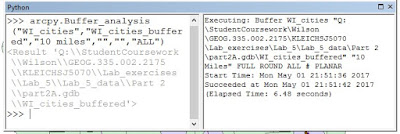 |
| Figure 2. Python script for 10 mile buffer of cities in Wisconsin. |
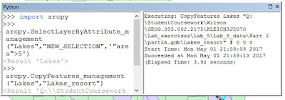 |
| Figure 3. Python script for lakes with an area greater than 5 square miles. |
 |
| Figure 4. Python script for clipping lakes that met criteria and buffered cities. |
 |
| Figure 5. Dataflow model to develop suitable areas for the development of tourist resorts in Wisconsin. |
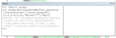 |
| Figure 6. Python script for making a multiple ring buffer around interstates in Wisconsin. |
 |
| Figure 7. Dataflow modeling air pollution impact zones around interstates in Wisconsin. |
Results:
Using the methods I performed above, I created three maps:
one of suitable bear habitats in Marquette County in Michigan, one of possible
lake resorts in Wisconsin, and one of air pollution hazards near interstates in
Wisconsin. Each of these maps are shown below.
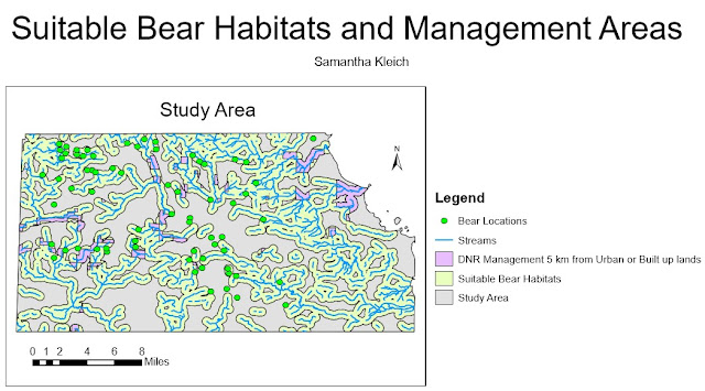 |
| Figure 8. Map of suitable bear habitats in Marquette County, Michigan. |
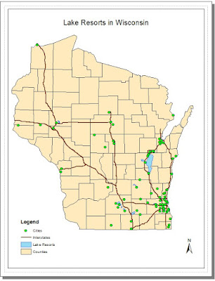 |
| Figure 9. Map of suitable lake areas for the development of tourist resorts. |
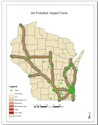 |
| Figure 10. Map of air pollution impact zones near Wisconsin interstates. |
Sources:
Esri2017 Database (2017) [downloaded file]. SQL Server. URL: geogsql.uwec.edu [May 2, 2017]
Michigan Department
of Natural Resources (2017) [downloaded file]. SQL Server. URL:
geogsql.uwec.edu [May 2, 2017]
Price, Maribeth. 2016. Mastering
ArcGIS. 7th Edition data. McGraw Hill. [downloaded file]. SQL Server. URL: geogsql.uwec.edu [May 2, 2017]
Wilson, Cyril 2012, A comprehensive Lake features for
Wisconsin, Unpublished data. [downloaded file]. SQL Server. URL: geogsql.uwec.edu [May 2, 2017]


No comments:
Post a Comment