This lab was my first experience in testing my skills of geographic information systems based on the knowledge I gained from lectures and tutorials in my Mastering ArcGIS textbook. The beginning skills I learned encompass information about coordinate systems, importing and exporting data, metadata, ArcCatalog, ArcToolbox, and projecting data. All of these were useful as I developed my maps throughout Lab 1. The goal of this lab was to evaluate my understanding of projected and geographic coordinate systems and manage unfit projections of GIS data. I was asked to create six world maps and a map of Wisconsin based on predefined projections as well as a single map showing rivers and streams that flowed through the counties surrounding Eau Claire. The ultimate goal for this lab was to use techniques I have acquired thus far to complete my final maps.
Methods:
I started this lab by downloading and unzipping the data I gathered from D2L. I did this in order to access the data in ArcMap for my personal use. I then began to add shapefiles to the dataframe in a blank map on ArcMap by using the Add Data tool. Once I added the shapefiles, I changed their symbols by double clicking on the symbol icon in the Table of Contents which pulled up the Symbol Selector tab where I chose different colors and styles. To change the name of the data frame I slowly double clicked on the current name which allowed me to rename it. After this, I right clicked on my new data frame name and chose Properties and then chose the geographic coordinate system, WGS 1984. I then continued to insert new data frames. For each data frame, I renamed it, added the correct shapefiles, and changed the Projected Coordinate System.
Next, I inserted another data frame and added the shapefile, states. However, this projected all of the United States rather than only the state of Wisconsin. Therefore, I used the Select Features tool and created a layer that contained only Wisconsin. From here, I used the data frame properties to once again change the data frame coordinate system; in this case, I chose NAD_1983_UTM_Zone_16N.
Then, I was asked to create another data frame with new shapefiles. From here, I had to change the projection of the stroads_miv5.shp by using the Project tool in the ArcToolbox. Finally, I switched to the layout view and began constructing a visually pleasing map that contained each of the seven maps I had just created.
After this, I started a blank new map and began by adding the shapefile containing central Wisconsin counties. I used the Project tool again to change the projection of this shapefile. I chose the geographic coordinate system, GCS_North_American_1983, based off the metadata and the projection system, NAD_1983_StatePlane_Wisconsin_Central_FIPS_4802,because theses counties are located within the central Wisconsin. I then repeated a similar process to this as I added the Lower_Chp_strms.shp shapefile. I gave the streams the Projected Coordinate System NAD_1983_StatePlane_Wisconsin_Central_FIPS_4802 as well because this data is also located in central Wisconsin.
Results:
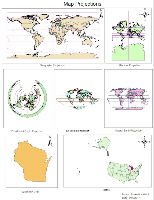
Figure 1 shows my final map containing various projections of the Earth including
Geographic, Mercator, Equidistant-Conic, Sinusoidal, and Natural Earth. The figure also contains a UTM projection of Wisconsin and a Lambert Conformal Conic projection of the United States. The solid color represents either countries or states depending on each of the seven maps and the lines on six of the maps show the geogrid.

Figure 1: Above is the final maps of six world maps and a Wisconsin map that demonstrate my understanding of geographic and projected coordinate systems.
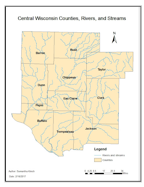
Figure 2 is a map I made that contains the counties of central Wisconsin that surround Eau Claire and the streams and rivers which run through these counties. The beige color displays the counties and blue represent rivers and streams.

Figure 2: This is a map of central Wisconsin counties and rivers and streams which run through these counties.
Sources:
Michigan Department of Transportation (2017) [downloaded file]. SQL Server. URL: geogsql.uwec.edu [February 16, 2017]
Price Mastering ArcGIS Database (2016) [downloaded file] SQL Server. URL. geogsql.uwec.edu [February 16, 2017].
No comments:
Post a Comment